How to use the Yellow Brick tracker and YB races app
An all you need to know guide for the Yellow Brick tracker, being a Dot Watcher and using the YB Races app during the Atlantic Dash.
What is a Yellow Brick?
A Yellow Brick Tracker – the YB3 – is a robust, waterproof, handheld device which tracks your location in regular intervals, YB Tracking then visualise that for us on a map.
YB is powered by the Iridium network. Iridium has 66 satellites in orbit around the Earth, allowing coverage anywhere on our planet 24 hours a day, 7 days a week (providing you have a clear view of the sky).*
A YB tracker attached to the outside of an ocean rowing boat in a waterproof case for protection
All boats in the Atlantic Dash will have a Yellow Brick tracker attached which is included in the event entry fee. A single full charge will last for about 2500 transmissions, so at 6 transmissions a day the YB battery will last for well over a year!
With some back up safety features – the ability to send and receive messages up to 250 characters and a big red sos button – the YB tracker is a very useful bit of kit to have on board.
We have a tracker map embedded into the website during the event which works in conjunction with windy.com so you can overlay information about the wind, waves, currents and even clouds. Perfect for the nerds!
The embedded map isn’t available to view on mobile platforms, but fear not, there is a handy app called YB RACES (search for YB Races in your app store) which you can download to your phone, so you can check it every morning straight after you’ve opened your eyes… did we warn you that dot watching is highly addictive?!
The YB Races App
Our favourite map features
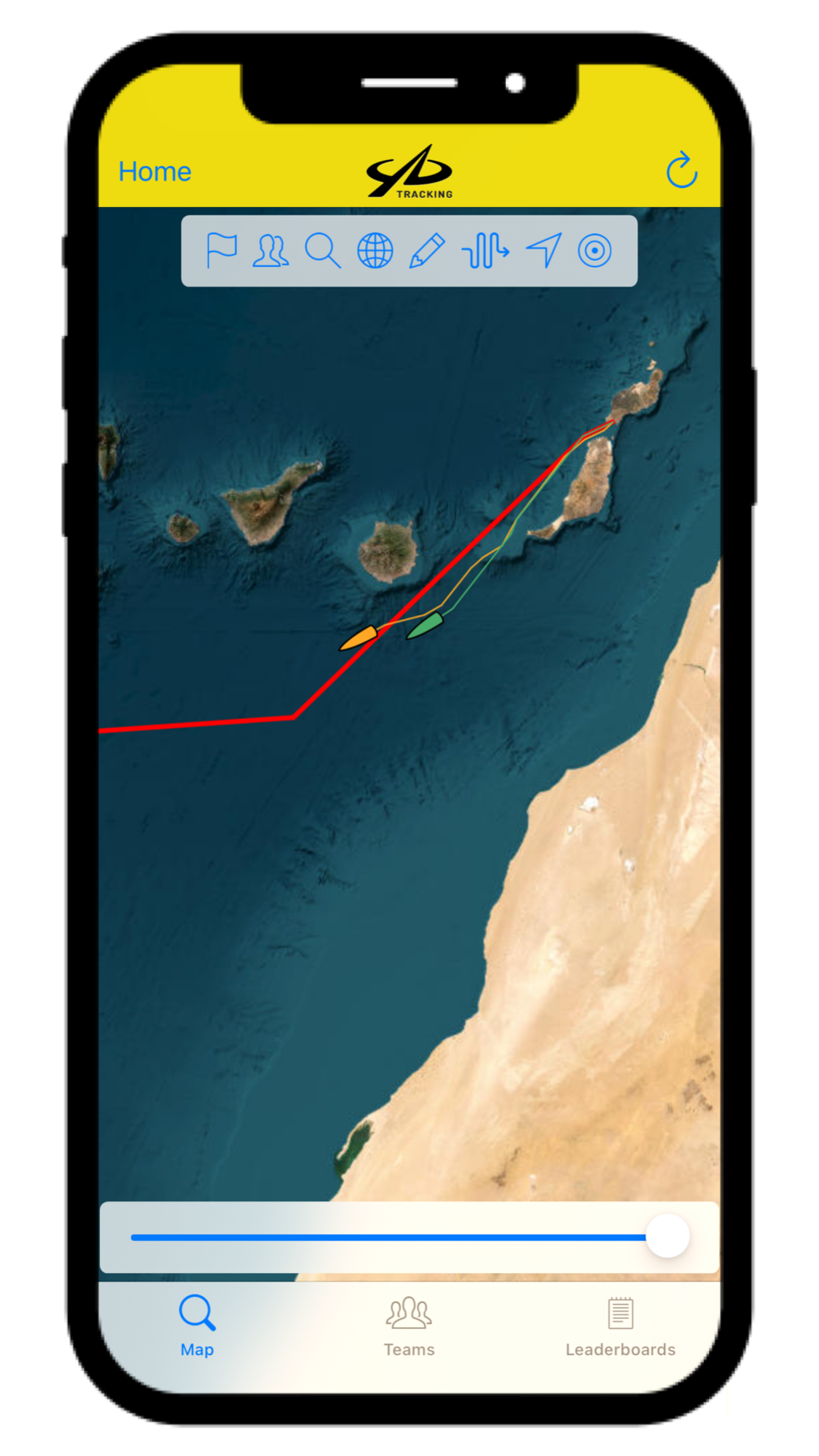
THE RED LINE: this shows the most direct route to from Lanzarote to Antigua. The Atlantic Dash crews will head south of this line to pick up the trade winds and hopefully find some helpful currents. The red line can be toggled on and off with the pencil icon.
GLOBE ICON: this allows you to switch between satellite or topographic maps.
WIND OVERLAY: the arrow icon allows you to toggle on and off an overlay of the wind direction and speed
SLIDER: one our favourite features is the slider at the bottom of the map, this allows you to travel back in time through the event and get an overview of the boats progress from the start of the event to their current position.
TEAMS / LEADERBOARD: the team tab on bottom of the map will give you more information and a picture of the crew in each team, and the leaderboard tab will give give information on speed, distance and time – which we have explained in the next section…
The red line showing the most direct route
Overlay showing the wind direction
The leaderboard
Each crew is listed and ranked by how close they are to Antigua, and while there are no winners as such in the Atlantic Dash, we’ve heard that the last one to Antigua buys the beers!
START TIME: the top date and time is the start of the event. This will stay the same throughout.
UPDATED: underneath the start time is the date and time of the latest ping from the YB tracker. During the first 48 hours the tracker will transmit every hour, after which it will change to transmitting every 4 hours.
DTF: Distance To Finish – the top number is the remaining number of nautical miles left to get to Antigua
ROWED: the bottom number is the accumulative number of miles rowed since the start of the event.
VMG: Velocity Made Good. This is the speed the boat is travelling. You can toggle between VMG START – the average speed of the boat during the whole event, and VMG RECENT – the speed of the boat during the 4 hours prior to the latest ping of the tracker.
LAST 24 HRS: the distance covered in the 24 hours prior to the latest tracker ping.
THE COLOURED TARGET: tapping on the coloured targets will take you directly to the crews position on the map.
Tapping on each crew name will give you an estimated time of arrival in Antigua, and an estimated number of days for the crossing. This date will vary a lot, especially in the early stages of the event, but it can be useful later on for family looking to book flights to Antigua.
How to download the YB Races app
The YB Races app is FREE to download and FREE to use!
Follow this link if you use an iPhone, or follow this link if you use an Android phone. Or you can just search for “YB Races” in your app store.
Once installed tap “Add Races” and search for “Atlantic Dash” and select the relevant year for the event you want to follow.
Sit back and watch the dots move every 4 hours 👀
All images taken from an iPhone YB Races app, set up may vary slightly on other devices but the definitions and functionality will be the same.
* Information taken from the YB Tracking website.


